The National Historic Preservation Act of 1966 is a U.S. law that establishes a national preservation program and a system of procedural protections, encouraging both the identification and protection of historic resources, including archeological resources. The National Historic Preservation Act represents the most extensive preservation legislation ever enacted in the U.S. It constitutes partnerships between the federal government and state, tribal, and local governments, supported by federal funding for preservation activities.
Section 106 of the National Historic Preservation Act
Section 106 of the National Historic Preservation Act requires federal agencies, like the Federal Highway Administration (FHWA), to consider the effects of a project on historic properties. Section 106 does not require historic properties to be preserved but does require agencies proposing projects using federal funds or requiring federal approval to participate in a consultation process that considers the effects the project will have on historic properties. The people and organizations involved in the consultation process vary by project but may include the State Historic Preservation Office (SHPO), the Tribal Historic Preservation Officer (THPO), federally recognized Indian tribes and Native Hawaiian Organizations, local governments, and the public. These groups are known as consulting parties.
Historic properties
In the Section 106 process, a historic property is a prehistoric or historic district, site, building, structure, or object included in or eligible for inclusion in the National Register of Historic Places. This term includes artifacts, records, and remains that are related to and located within these National Register properties. The term also includes properties of traditional religious and cultural importance to an Indian tribe or Native Hawaiian organization, so long as that property also meets the criteria for listing in the National Register. - Advisory Council on Historic Preservation
Determining whether a place holds historical significance in the United States requires a careful examination of several factors. The primary guide for this evaluation is the National Register of Historic Places, which employs a set of four core criteria to determine whether a site, building, or object warrants recognition and protection. The review identified location along the corridor with historical significance. For more information, visit the Advisory Council on Historic Preservation and the selection process.
Section 106 review of the Hwy 252/I-94 project
During the Hwy 252/I-94 project, our team at MnDOT identified historic properties in the project area to assess project effects on the properties.
The historic properties within the project’s Area of Potential Effects are:
Upper Harbor Historic District
The Upper Harbor Historic Districts eligible for the National Register under Criterion A in the area of Commerce, Maritime History, Industry, and Transportation. The period of significance is from 1948, the year dredging of the Mississippi River began upriver from the Washington Avenue Bridge, to 1976, the year that river shipping peaked in Minneapolis. Character-defining features include two bridges, barge dock, boat ramp, terminal complexes, and sitting along the Mississippi River.
The Upper Harbor Historic District is significant because it tells the story of how trade, river shipping, and industry developed in Minneapolis. This district was substantial from 1948, when dredging of the Mississippi River began north of the Washington Avenue Bridge, until 1976, when river shipping was at its busiest in Minneapolis. You can recognize this district by its key features, including two bridges, a barge dock, a boat ramp, and shipping terminals along the Mississippi River.
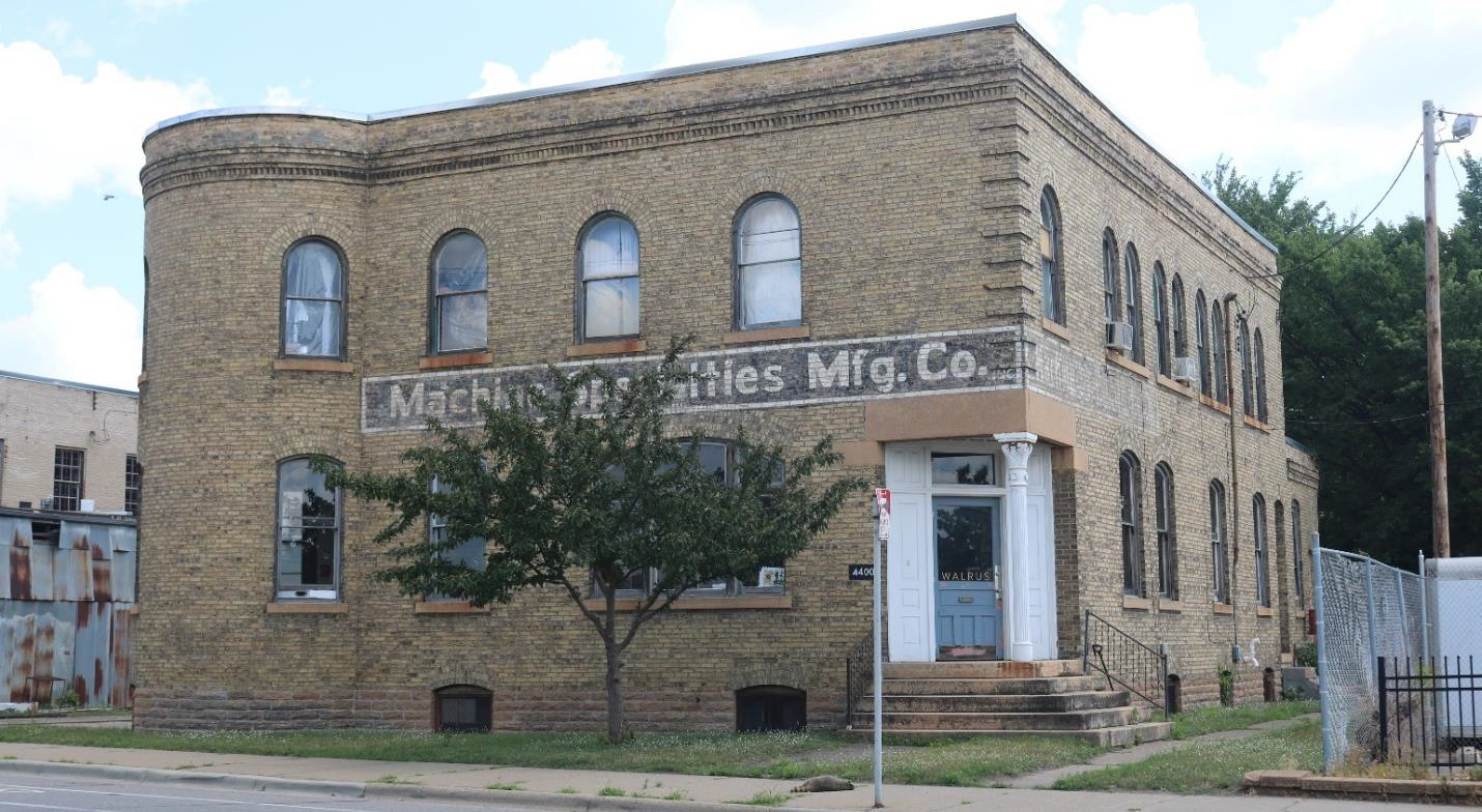
Minneapolis Warehouse Historic District and the LaVoris Chemical Company Building is contributing to the district
The Minneapolis Warehouse Historic District is listed on the National Register under Criterion A and C for its connection with early Minneapolis commercial growth and as the city’s warehouse and wholesaling district that expanded in the late 19th and early 20th centuries. Character-defining features include three-stories tall commercial buildings, large 5-to-7 story tall utilitarian structures, steel bridges, brick or cobblestone streets, and rectangular street grid.
The Minneapolis Warehouse Historic District is recognized for its important role in Minneapolis's early commercial growth, serving as the city's main area for warehouses and wholesale businesses that grew rapidly in the late 1800s and early 1900s. It's also recognized for its significant architecture and design. Key features that define this district include three-story commercial buildings, taller 5-to-7 story industrial-style buildings, steel bridges, streets made of brick or cobblestone, and its organized, rectangular street layout. The LaVoris Chemical Company Building is a notable part of this historic district.
Lyn Park is eligible for the National Register under Criterion A in the areas of Ethnic History and Community Planning and Development. Character-defining features include the cul-de-sac and pedestrian pathway circulation patterns, approximately 7,000-square-foot lot size, and Split-level, Ranch, or two-story house types with a mix of materials, often brick or fieldstone at the base, and horizontal wood siding, attached garages, and sconces framing the garage and front doors. The period of significance extends from 1976, with the completion of the first residence, to 1986, when the continuous waves of development ended.
The Lyn Park Subdivision is important for its ethnic history and how the community was planned and developed. It was significant from 1976, when the first homes were finished, until 1986, when most of its development stopped. Key features of Lyn Park include its circular streets (cul-de-sacs) and walking paths, average lot sizes of about 7,000 square feet, and typical home styles like split-level, Ranch, or two-story houses. These homes often use a mix of materials, such as brick or fieldstone at the bottom and horizontal wood siding, and have attached garages with decorative lights (sconces) framing the garage and front doors. The historic area includes the legal boundaries of its first six additions.
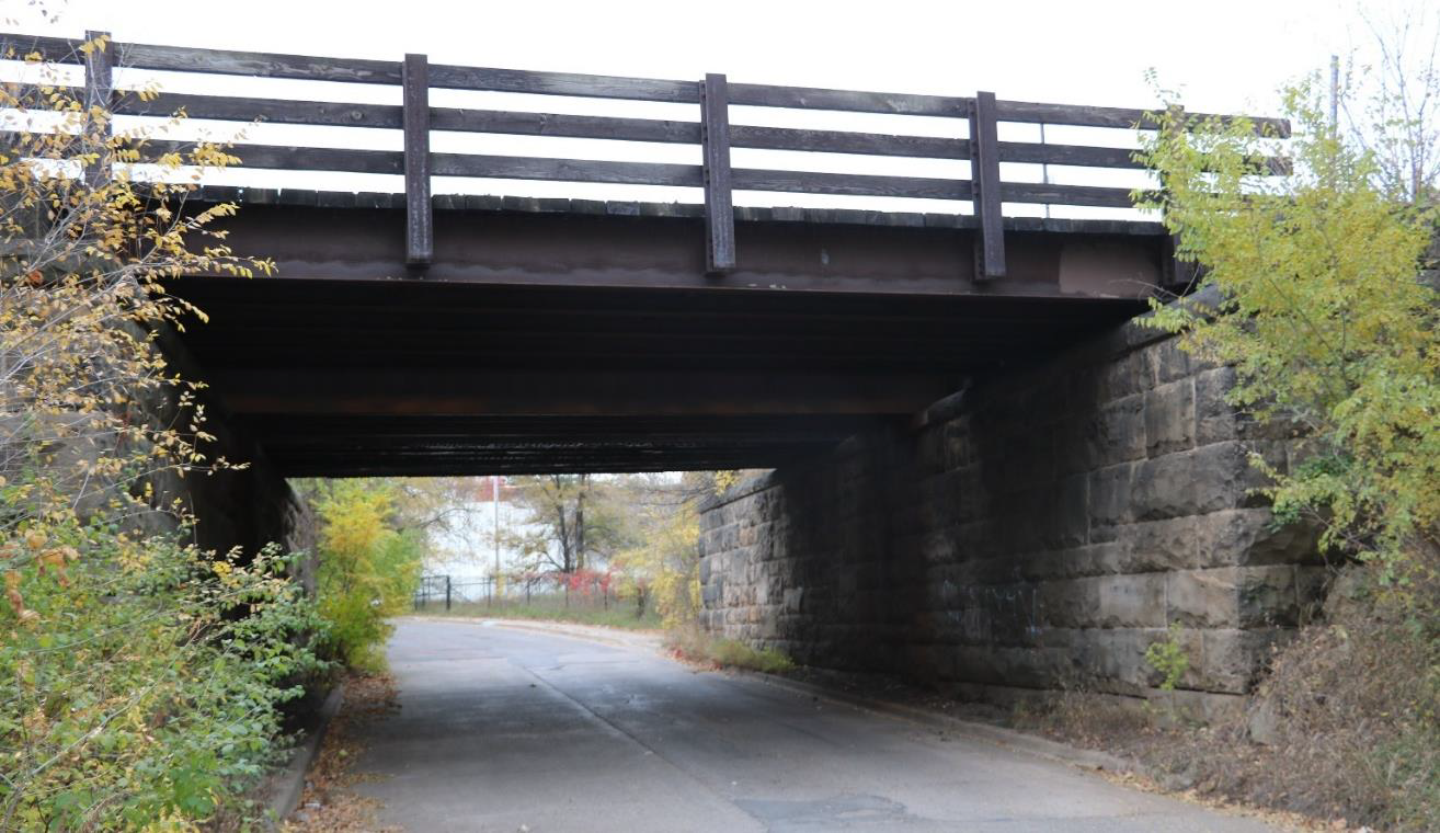
Soo Line Rail Corridor/Minneapolis and Pacific Railroad Company/Minneapolis St. Paul & Sault Ste. Marie Railroad Corridor
The Minneapolis and Pacific Railroad Company/Minneapolis St. Paul & Sault Ste. Marie Railroad Corridor is eligible for the National Register under Criterion A in the area of Transportation, with a period of significance of 1886 to 1930.
Grand Rounds Historic District
The Grand Rounds Historic District is eligible for the National Register under Criterion A in the area of Community Planning and Development and under Criterion C for Landscape Architecture with a period of significance of 1884 to 1942. Grand Rounds is a system of parks and parkways established by the Minneapolis Board of Park Commissioners that encircles most of Minneapolis. Webber Park, Webber Parkway, and Camden Bridge (Bridge 27549) are the individual resources within the Grand Rounds Historic District in the project area.
C.A. Smith Lumber Historic District; C.A. Smith Lumber and Compo-Board; C.A. Smith Lumber Company Office
The C.A. Smith Lumber Company is eligible for the National Register under Criterion A: Industry for its association with the early Minneapolis lumber industry, Criterion B: Significant Person for its association with C.A. Smith, and Criterion C: Architecture as intact examples of turn-of-the-century factory and office buildings on industrial complexes. Character-defining features of the warehouse include the predominantly open floorplan, flat roof, regular fenestration, and fireproof construction. Character-defining features of the office include the siting and design, which physically sets the office apart from other buildings in a two-story masonry building that is also architecturally distinct from the other buildings on the site. The interior has distinct office spaces on the first floor, typical for an early-twentieth-century office plan. The period of significance is 1892 to 1939, which spans from the year of construction until the last year Compo-board was produced on site. The historic boundary is the two parcels occupied by the remaining buildings: the compo-board factory and the office building.
The C.A. Smith Lumber Company Historic District is recognized for its historical significance in several ways: its strong connection to Minneapolis's early lumber industry; its association with important person, C.A. Smith; and for its well-preserved factory and office buildings from the turn of the 20th century. The significant period for this site spans from 1892 to 1939, covering its construction and the final year the 'Compo-board' product was made here. The main warehouse building stands out with its largely open interior, flat roof, evenly spaced windows, and fireproof construction. The office building is distinct in its placement and design, a separate two-story brick building with unique architectural details and an interior layout typical of early 1900s offices. The historic area includes the factory and office buildings that remain.
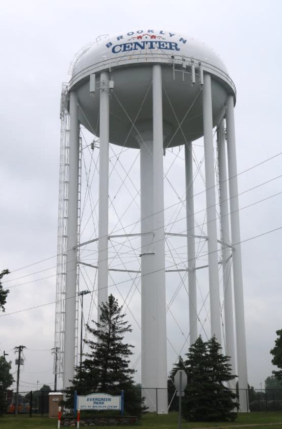
The Brooklyn Center Water Tower is eligible for the National Register under Criterion A: History for its role in the development of the community of Brooklyn Center. The period of significance is 1960, the year the water tower was erected. The water tower retains all character-defining features, which in this case includes the original tower structure, equipment shelters, and pump house. The historic boundary corresponds to the parcel on which the tower sits, which is located at the southwest corner of a larger lot that contains of Evergreen Park.
The Brooklyn Center Water Tower is significant for its role in the growth of the Brooklyn Center community. It was built in 1960, which marks its period of significance. The water tower still has all its original key features, including the tower itself, equipment shelters, and the pump house. The historic area is the plot of land where the tower stands, located at the southwest corner of the larger Evergreen Park lot.
Lowry Substation/Minneapolis Street Railway Co. Powerhouse No. 28
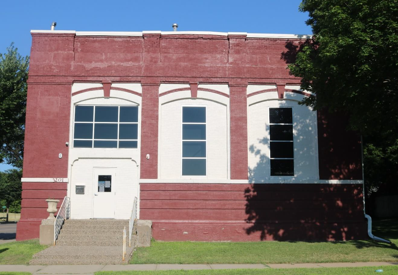
The Lowry Avenue Substation/Minneapolis Street Railway Company Powerhouse No. 28 is eligible for the National Register under Criterion A: History as an example of an electric power substation, an integral component of the Twin Cities streetcar system. Character-defining features include the square, approximately 50-foot by 50-foot footprint; the open interior space; and the largely symmetrical facades with arched window openings. The period of significance begins in 1908, the year of construction, and extends to 1954, when buses replaced electric streetcars and the substation became obsolete. The historic boundary is the two parcels that the building occupies.
The Lowry Avenue Substation (also known as Minneapolis Street Railway Company Powerhouse No. 28) is important because it was a key part of the Twin Cities' electric streetcar system. It was significant from 1908, when it was built, until 1954, when buses took over from streetcars and the substation was no longer needed. Key features of this building include its square shape (about 50 feet by 50 feet), its open interior, and its mostly symmetrical outside walls with arched window openings. The historic area covers the two plots of land the building sits on.
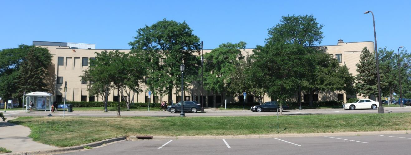
Control Data Institute; Control Data – Northside Manufacturing Plant
The Control Data Institute and Northside Manufacturing Plant are eligible for listing in the National Register under Criterion A: Social History. Character-defining features of the institute include the interior corridors, lobbies, and office spaces, and the Modernist design elements including the flat roof, clean lines, and simple corbeled brick pilasters. Character-defining features of the warehouse include the flat roof, limited fenestration, and vertical articulation. The period of significance is from 1968, when the plant was constructed, to 1988, when both the plant and the institute were closed. The historic boundary encompasses both the parcels of the institute building and the manufacturing plant.
The Control Data Institute and Northside Manufacturing Plant are important for their social history. They were significant from 1968, when the plant was built, until 1988, when both the plant and institute closed. Key features of the institute building include its hallways, lobbies, and office spaces, along with its modern design elements like a flat roof, straight lines, and simple decorative brick columns. The manufacturing plant (warehouse) is defined by its flat roof, few windows, and tall, narrow design elements. The historic area includes the land where both the institute and the manufacturing plant buildings are located.
Next steps
The upcoming phases of this project will involve evaluating the impact on historic properties and addressing any effects, if necessary.
The next steps for this project include assessing effects of the project on the historic properties and resolving any effects, if applicable. For more information or if you would like to comment on historic properties or project effects related to historic properties, contact Maggie Jones with MnDOT's Cultural Resources Unit at Maggie.Jones@state.mn.us or 651-392-5424.